
Discover
Discover the World Heritage on your own screen! With the help of the map, films and animations, you can learn what makes the High Coast and Kvarken Archipelago unique.
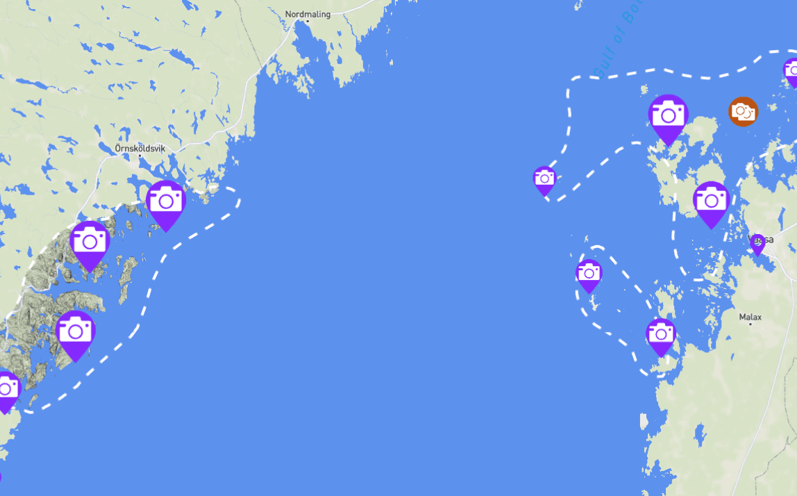
Experience the World Heritage with the interactive map
Here you will get a complete picture of the High Coast and Kvarken Archipelago. The map shows interesting places with films and 360-pictures. Explore the time line of the land uplift and the map layers that show where the traces of the ice age and land uplift can be found. Click the link below!
Get to know our geology with animations
Why is the High Coast steep and hilly and the Kvarken Archipelago flat and low? It is not because of the land uplift.
Why do we have so rapid land uplift in the World Heritage area? How much has the land risen and how much new land do the World Heritage get from the sea every year?
Will the land still rise in the future? Can the sea-level rise faster than the land uplift in our world heritage?
How can we find traces of the ice age 10 500 years after the ice melted away? How thick was the ice?
How were the traces of the Ice Sheet and land uplift created?
How where these moraines formed by the melting ice? How large are these moraines? Where can these be found?
What is the difference between High Coast and Kvarken Archipelago? Why are these lagoons so important for fishes and birds?
Why are these smooth caves shaped like onions? What are the similarities with giants’ kettles?
Tunnel caves – Why are these smooth caves shaped like onions? What are the similarities with giants’ kettles?
Why are cobble fields older the higher up they are? How are the beach ridges on the cobble fields formed?
What does the traces of the Ice Sheet look like?
Moraine Ridges – Why are so many islands in Kvarken Archipelago long and narrow? And why are many islands only a few hundred years old? English subtitles are available.
Boulder terrain – Why is the ice sheet responsible for the vast areas of boulder terrain found in Kvarken Archipelago? English subtitles are available.
What does the traces of land uplift and the sea look like?
Till-capped hills – How can these hills with their hats of forests show the highest coastline? How can we still see this line after over 10 000 years? English subtitles are available.
Tunnel Caves – How has the power of the sea formed these smooth caves? Why are they common in the High Coast? English subtitles are available.
Cobble Fields – Why are these called “the devil’s fields” in Finland? Why are all the stones in them rounded? English subtitles are available.
How is the nature affected by the land uplift?
Off-cut Bays – Why have all lakes in the High Coast once been a part of the sea? How can one know these lakes once was a bay in the sea? English subtitles are available.
Flads and gloes in Kvarken Archipelago – What is a flad and a gloe? Why are these lagoons so common in Kvarken Archipelago? English subtitles are available.
Land Uplift Forests – How do nature colonize the new land risen from the sea? It happens quickly and in the same way. English subtitles are available.